Projects
Apps, websites and tools I've built or co-created.
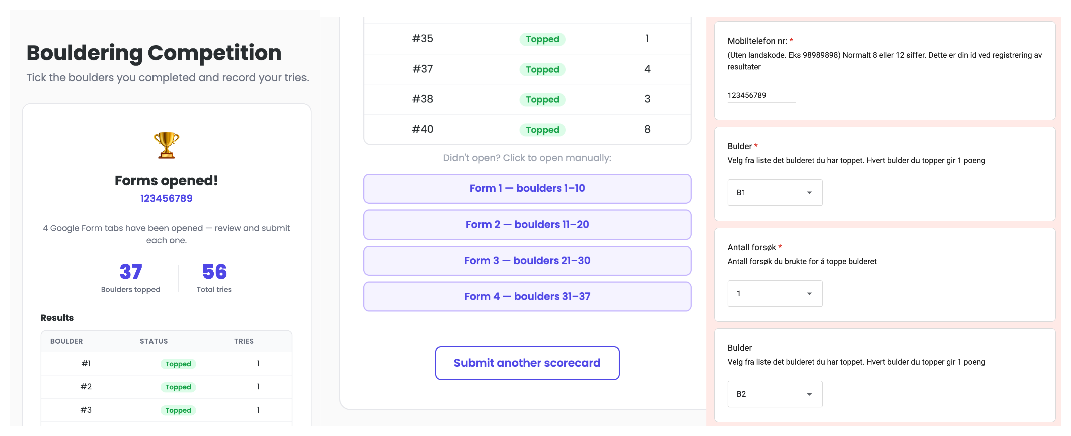
Better Form Submission
Mini web-app to make the form submission for bouldering competitions less painful.
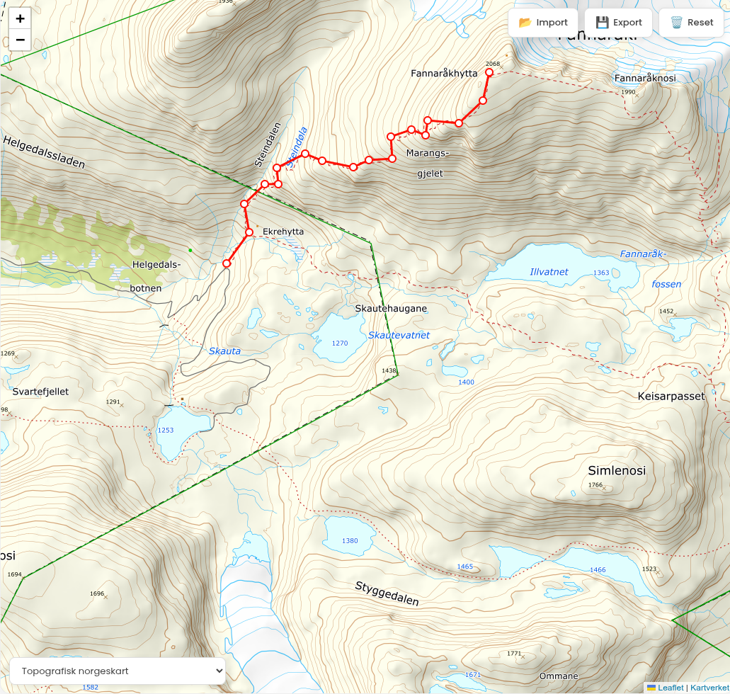
Norgeskart GPX
A web application for creating, viewing, editing and exporting GPX tracks specifically using Norgeskart in Norway.
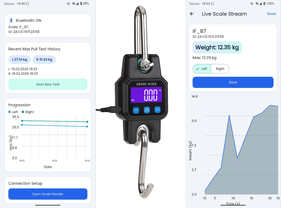
Pull Strength BLE
A Flutter app for Android that connects to a BLE crane scale (WeiHeng WH-C06 compatible), decodes live readings and tracks pull strength tests.
Publications
Selection of peer-reviewed papers, conference presentations, and other research outputs from my work.
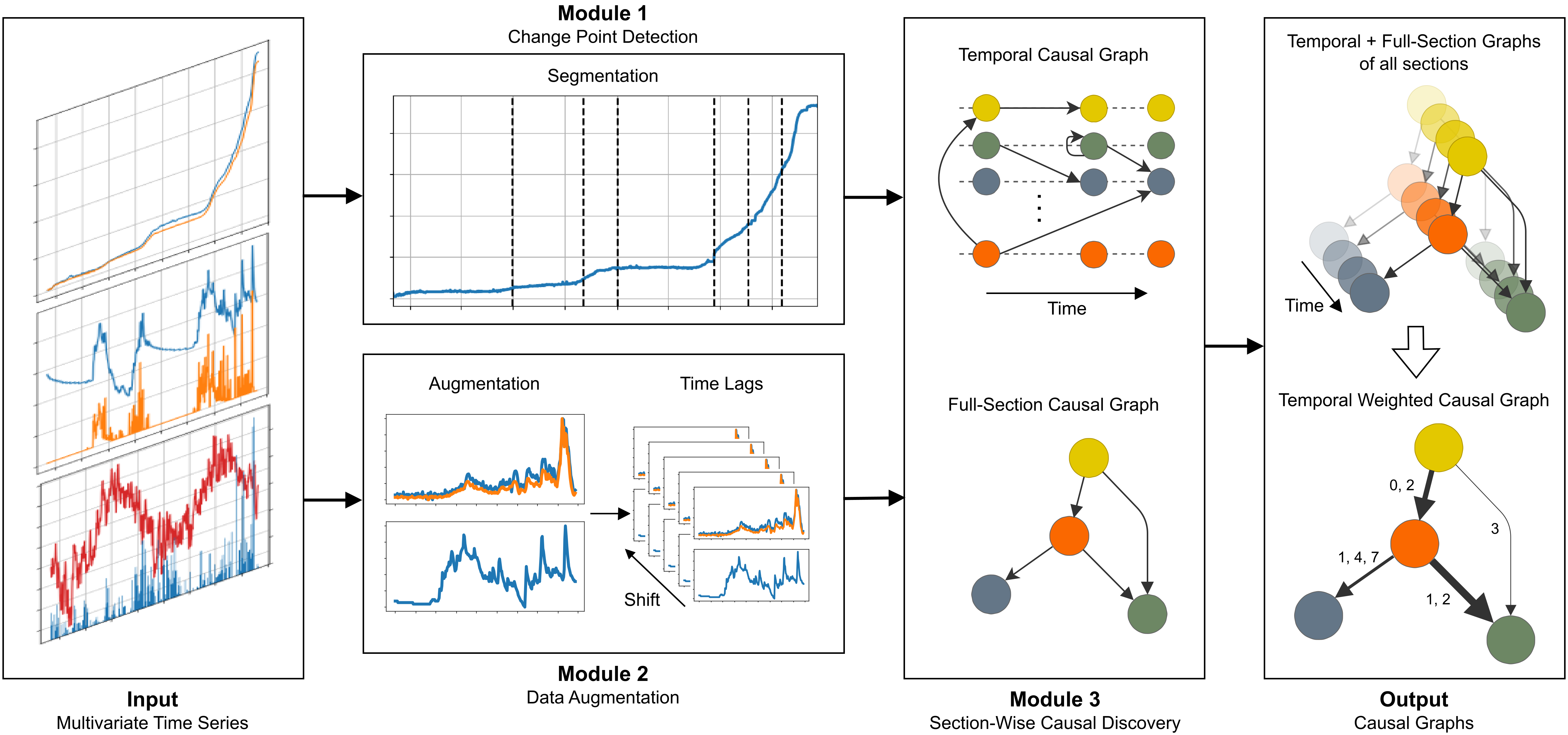
Exposing the potential of XAI-based causal discovery for analysing unstable rock slopes
Nature Scientific Reports
Unstable rock slopes pose significant challenges in geohazard analysis due to their complex nature. Traditional approaches to understanding displacement drivers on unstable rock slopes limit conclusive statements on process drivers, focusing on statistical analyses and expert knowledge. eXplainable Artificial Intelligence (XAI) based Causal Discovery enables the unbiased construction of causal graphs, depicting the cause-and-effect relations between system variables, beyond statistical correlations. In this study, we use Multi-Window Causal Discovery (MWCD) for creating causal graphs from pre-failure displacement and weather monitoring data applied to three different sites. At the Stampa rock section 4a (Norway), MWCD identifies a temporal shift from an indirect to a direct effect of precipitation and infiltration on the displacement, corresponding to a final destabilization. In Preonzo (Switzerland), causal connections change considerably during the pre-failure acceleration from temperature and precipitation dominated effects to a gravitationally driven system. At Veslemannen (Norway), MWCD identifies spatial causality with lower sections of the instability strongly influencing the deformation dynamics of the upper sections. Our results show that incorporating XAI-based methods alongside traditional geological analysis drastically improves the understanding of displacement dynamics in unstable rock slopes. This improved understanding can be used to build more robust and accurate forecasting methods.
Explainable Artificial Intelligence Based Displacement Analysis and Forecasting for Unstable Rock Slopes
EGU General Assembly 2025
Geohazards such as landslides, rock avalanches or rock falls from unstable slopes can seriously threaten human life and infrastructure. Monitoring unstable slopes coupled with real-time data analyses to assess the risk they pose and mitigate this risk is thus indispensable. Machine learning-based methods for analysing monitoring data recently significantly improved the forecasting possibilities for failure events. However, one major limitation of Machine Learning-based methods is that they primarily provide "Black Box"-models. These models can, for example, transform arbitrary input into a sequence of predictions, albeit without a transparent explanation of how the output is derived from the input. Even though State-of-the-Art Machine Learning often outperforms traditional failure forecasting methods, such as the Inverse Velocity method, this limitation greatly hampers the application of these methods in practice. Recent advances in eXplainable Artificial Intelligence (XAI) have led to the development of the field of Causal Artificial Intelligence. As opposed to many Machine Learning approaches which are based on Deep Neural Networks, XAI aims to offer transparent models that provide explanations for model outputs. We therefore propose a novel forecasting approach based on XAI, leveraging Graph Neural Networks and Kolmogorov-Arnold Networks. Our approach aims to learn a causal model of an unstable slope or one particular section of it, including slope-internal and meteorological factors that can be represented as a graph, visualising cause-and-effect relationships between the variables. As such, our goal is twofold, and we aim at (1) providing insight into the mechanisms driving slope displacement, and (2) using this information for explainable short-term forecasting by selecting only causally related features from all available data. We apply our method to two case study sites for displacement driver analysis and short-term displacement prediction and compare the model performance to recent State-of-the-Art models. Our method not only aligns with but even outperforms existing models in terms of prediction accuracy and offers, in addition, superior interpretability. The proposed framework provides crucial support for geohazard assessment and monitoring network design. Furthermore, the displacement prediction has great potential as standalone predictive network as well as for hybrid failure prediction methods, for example in combination with traditional long-term failure predictions such as the Inverse Velocity method. While developed with medium-scale rock sections in mind, the method may be adapted to larger rock volumes as well as slow-moving mass movements with failure potential in general. The usage of accurate and interpretable prediction models represents a significant advancement, overcoming the transparency issues of models generated by complex Artificial Neural Networks, ultimately contributing to improving Early Warning Systems.
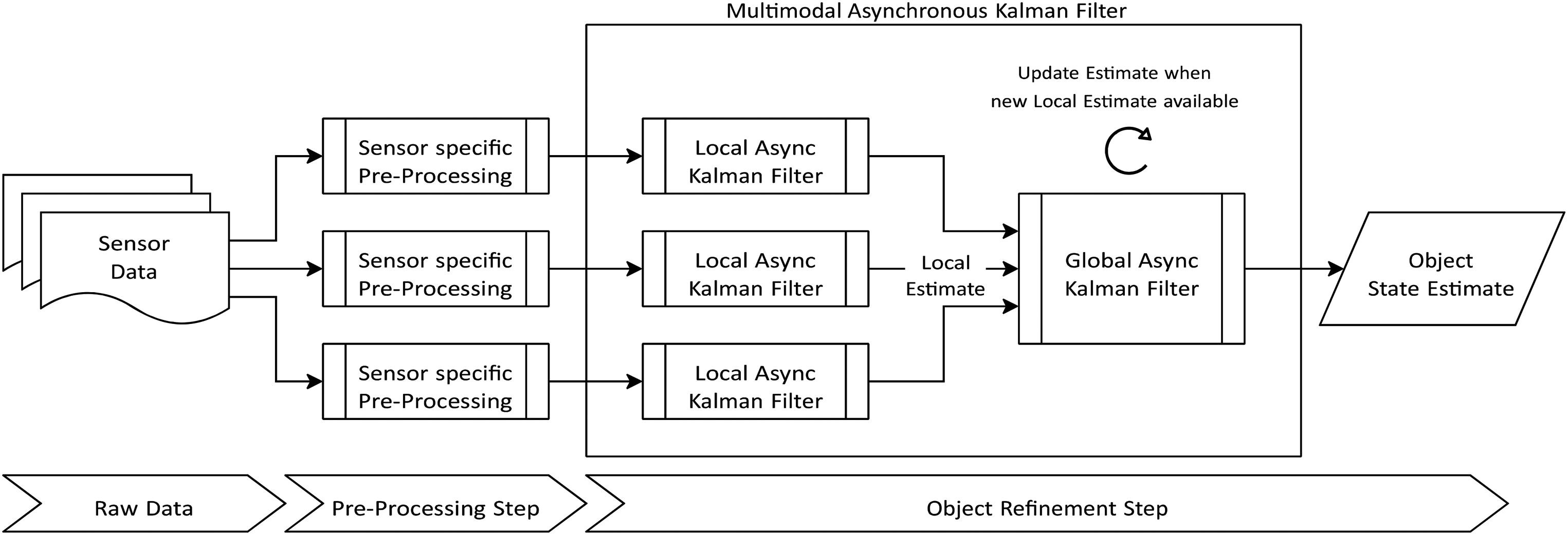
Multimodal Asynchronous Kalman Filter for monitoring unstable rock slopes
Geomatics, Natural Hazards and Risk, 14:1, 2272575
Unstable rock slopes pose a hazard to inhabitants and infrastructure in their vicinity, necessitating advanced monitoring methodologies for timely risk assessment and mitigation. Recent geotechnical monitoring techniques often rely on sensor data fusion to enhance forecasting for imminent failures. Our investigation extends beyond a single sensor type to data fusion for heterogeneous sensor networks using a Multimodal Asynchronous Kalman Filter. We illustrate the application of the proposed method on a case study data set consisting of data from an on-site sensor network enriched by remote sensing data. Employing a Multimodal Asynchronous Kalman Filter, we capitalise on the distinct resolutions inherent in each sensor input. The outcome was a combined dataset with a high spatiotemporal resolution. Our approach facilitates the estimation of essential physical attributes for monitored objects, encompassing translation, rotation, velocities and accelerations. The case study site was an unstable rock section of ca. 50.000 m3 in Aurland, Norway, which collapsed as a multi-stage failure in July 2023. Our method can be transposed to various sites with distinct sensor networks, enhancing state estimations for objects on unstable rock slopes. These estimations can significantly improve applications such as risk assessment and robust early-warning systems, enhancing predictions of critical failure points.
Latest Blog Posts
Technology, engineering, research, and building things.
Large Language Models: Scaling New Heights
Introduction to Large Language Models, explaining the basics of LLMs and their scaling capabilities. Overview over the challenges LLMs face and the novel approaches chosen to enhance their performance.
Exposing the potential of XAI-based causal discovery for analysing unstable rock slopes
Plain english summary of the publication on XAI-based causal discovery for analysing unstable rock slopes.
Multimodal Asynchronous Kalman Filter for monitoring unstable rock slopes
Plain english summary of the publication on Multimodal Asynchronous Kalman Filters.